 |
 |
 |
 |
 |
 |
|
|
|
Partners:
Frank Konsella
Route Description: Climbed from Cloyses Lake trailhead, descended down East Face couloirs. Data: Began from Cloyses Lake trailhead at 10,860 around 9 am. Reached summit (14,003) at 2 pm. Approximate ski descent to l2,600 ft. Reached bottom of couloir at 3pm, returned to car at 5pm. Total vert skied: 1400'. Total vert climbed: 3143'. Total time: 8 hrs. Relevant Links: TGR Trip Report |
|
Report:
Frank and I met in Leadville the night before, with the intentions of skiing Mt. Massive. But, we took a better look at the peak and realized it was pretty thin and the approach was long. So, last minute we changed plans: We'll do Huron instead. We knew Huron was thin, but we'd seen lines down it while on La Plata the week before. We were pretty sure we could fine a line that went, and the approach was not as long as Mt. Massive (Okay, so maybe we were lazy :rolleyes2 ). Huron peak is in the Northern Sawatch Mountains, as are many of the other peaks we've been tackling lately like La Plata and Elbert. Spots of the Northern Sawatch are holding snow well this summer, so we were hoping to find some of that on Huron. Huron's elevation is supposedly 14,003 feet, making is just BARELY a fourteener. Question is, what if one of these days we recalculated elevations and it turns out Huron is 13,999 feet. Will that throw the fourteener world into an uproar??? :) :) The drive in to Huron was one of the more difficult tasks- we were accessing Huron from the Rockdale Trailhead (Cloyses Lake) which is little used. Most people take the South Fork of Lake Creek Trail from Winfield to reach the peak of Huron, from it's west side. But the west side of Huron has no snow, but the east side does, and the Rockdale Trailhead works it's way up the east side of Huron. Okay, now back to the story of why the drive was so difficult. So, Rockdale is this little old town, a row of cabins basically, on a dirt road. From here you turn onto another more rugged dirt road. The book talks about crossing the creek there like it's nothing. Yeah, um, nothing. The sun had set and it was twilight now, and there was the creek staring us in the face. But it wasn't a creek, it was a downright river. And at the other end of the river was a deer. The deer was staring us in the face with a look that said, "What the HECK are you guys doing???? No way you're going to make it across this creek." Well, we tried it anyway. A much better option than swimming and then walking up the other side of the road for miles. The creek, I mean river, was easily 3 feet deep at times. We made it to the other side, and the deer ran away. It didn't stick around for our victory celebration :( Anyway, the road came to a dead end, and we camped there that night. The next morning we got a bit of a late start. We started our hike on a trail that looked like it went somewhere, but then we realized it was not going to Huron. It was going up the valley. So, we turned around and backtracked to a point where it looked like we should be going up Huron. We bushwhacked a bit, and then found the trail. Now, when I say “trail”, I mean that quite loosely. As I said before, this trail is not widely used, and you can tell that by how many fallen trees we had to climb over, and by how many times we lost the trail and had to look around to get back on the trial. Nevertheless, the scenery was beautiful. Frank crossing a stream.
Loved this meadow!!!
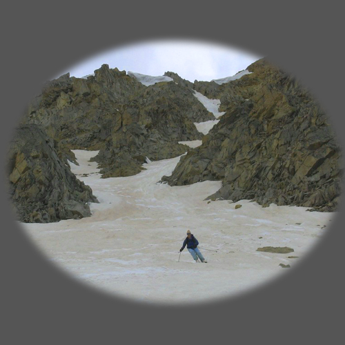
Um, yeah, we are here to ski THIS:
But first we have to get up this saddle, and work our way to the peak.
The summit register was actually not buried under snow and was not frozen shut. Yay. So, I got to sign my first summit register of the year! Yay! Any idea what actually happens to those things??? Frank at the summit, ready to ski!
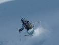
Frank ready to drop in to the couloir.
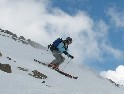
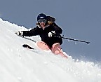
Making the turns!
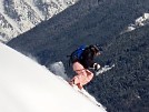
Frank is the only skier I know who loves runnels. He continuously made runnel jumps like this:
And on one of the runnels he pulled a full on spread-eagle! SWEET! So sad I missed that photo op! But I didn’t miss this one- Frank turning a runnel into a rail slide! Why go to the park when you can ski summer runnels???
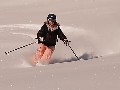
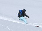
Okay, my turn. :)
Looking back up the couloir we had just skied.
When we got down to the bottom of the snow, we packed up our skis and boots for the hike down, and as I open my backpack, I pull out something VERY important… and realized I FORGOT TO WEAR MY LEI!!!!! I was so bummed! I have decided this TR needs to be decorated with flowers, somehow. So, here is my parting shot:
|
Photos contributed by Frank Konsella.


